Visions of the Celestial Empire
dal 23/9/2008 al 8/11/2008
Segnalato da
23/9/2008
Visions of the Celestial Empire
University Museum and Art Gallery - UMAG, Hong Kong
This exhibition presents the history of Western cartography of China from the 15th to 19th centuries. The show includes over 40 special loans of original Chinese and Western maps from the World Cultural Relics Protection Foundation, as well as over one hundred examples of maps of Asia and China and printed maps, representing the Italian, Portuguese, Dutch, French, German and British cartographic schools.

This exhibition presents the history of Western cartography of China from
the 15th to 19th centuries, a period in which major developments in Western
intellectual thought, especially during the Renaissance and the
Enlightenment periods, altered forever perceptions of the world. The
exhibition is co-presented by the Consulate General of Italy in Hong Kong,
The University Museum and Art Gallery, HKU and Champion Technology, and has
been organised by the Martino Martini Centre of the University of Trento in
Italy.
Maps may be considered the first expressions of a desire to depict knowledge
of the known world in a single interpretation. The most efficient and
systematic method of disseminating such information was in printed
collections: the atlas. The exhibition includes over 40 special loans of
original Chinese and Western maps from the World Cultural Relics Protection
Foundation, donated by Mr Paul Kan, as well as over one hundred examples of
maps of Asia and China reproduced from hand drawn and printed maps,
representing the Italian, Portuguese, Dutch, French, German and British
cartographic schools.
The European fascination with China provided the motivation for many
expeditions. Of particular importance were the Italian Jesuits such as
Matteo Ricci and Martino Martini, who travelled to China in the 17th
century. There they discovered an ancient, sophisticated and scientific
cartographic tradition that they studied and incorporated into their work
using European instruments to make the most accurate maps of their day.
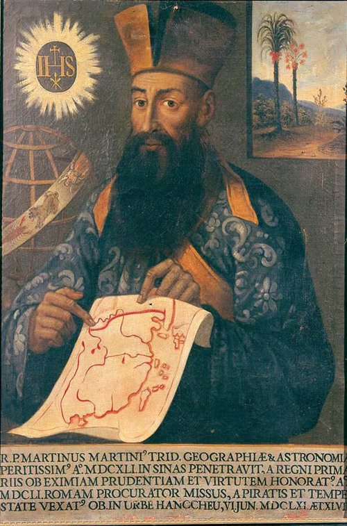
Father Martino Martini (1614-1661) exemplifies this period of great dialogue
and exchange between Europe and China. Sent to China in 1640, he traveled
throughout the country during the difficult years between the Ming and the
Qing dynasties, conducting astronomical, geodetic and topographic
observations. On his way back to Europe in 1651, Martini was captured by a
Dutch ship and held prisoner for a year in Batavia (Jakarta), the centre of
the Dutch colonial empire. Officials of the Dutch East India Company
examined his papers, among which was an atlas that he had drawn up, which
they translated. In 1655, Blaeu's publishing company published Martini¡¦s
Novus Atlas Sinensis containing 17 maps, with coordinates of 2,100 resorts,
and 170 pages of text with information about provincial borders, general
features, customs, products, administration etc. A number of original
prints of his 1655 atlas will also be on display.
The exhibition opening will take place on Tuesday 23 September at 6:00 pm.
Mr Alessandro De Pedys, Consul General of Italy in Hong Kong; Dr Paul Kan,
Chairman of Champion Technology; Professor Riccardo Scartezzini, Director
of the Martino Martini Centre, the University of Trento; and Professor
Joseph HW Lee, Pro-Vice-Chancellor, HKU will officiate. Members of the
press are warmly invited to attend.
To coincide with the exhibition, The Centre of Asian Studies, HKU; The
Martino Martini Centre of University of Trento in Italy; and the UMAG are
pleased to present an academic workshop entitled "Cartography and
Instruments in East and West", in the morning of Wednesday 24 September 2008
at the Museum. The workshop is supported by the Consulate General of Italy
in Hong Kong.
For further information about the exhibition, please visit:
http://www.hku.hk/hkumag, or call 2241-5512
Image: Portrait of Martino Martini, 1661, oil painting, Collection of Buonconsiglio Castle, Trento
University Museum and Art Gallery - UMAG
94 Bonham Road, Pokfulam (University of Hong Kong) - Hong Kong Cina
The Museum's opening hours are 9:30 am to 6:00 pm on weekdays and 1 to 6 pm on Sundays


